Showing posts with label Hiking. Show all posts

Friday, January 2, 2009

Stealing Away

There's something exciting about heading off for an adventure in the pre-dawn hours, especially on a day normally reserved for laboring at the Death Star.

Previously, I alluded to a future rambling simply titled "Close In, Far Out". Pardon the cliche, the future is now.

I'm hoping to keep a series going that details my hikes to show what is close enough to fit into a day trip.

Congratulations to the Poole's Pooches (poolie and ykngld) for correctly guessing the location of our adventure. However, I'm highly disappointed that you have not visited this location yet and you are hearby signed up for the next trip. Nevertheless, keep an eye on your mailbox. There's a $10,000 third party, out of state check heading your way! You'll notice that it's considerably more than the prize amount. All you need to do is deposit the check and send back the difference to cover promotional and advertising costs...


I love being the first out on the trail which is why we left before dawn to get up there as soon as the gates opened. Cloudland Canyon is about a 1.5-2 hr drive from home base (30 mins from ATL proper). There is one main trail that loops the east and west rim of the canyon. I think it's 4-6 miles. The majority of the hike is level ground, but there are also some sections with large rocks to traverse and the descent/ascent through the gorge can be steep.

The views are totally worth the effort...


The recent rain made for better waterfalls this time!


Had Riley not been with me I would have gone down to the falls for some better pictures. However, the path to the gorge floor is mostly man-made and there are several staircases with metal expansion steps. We've learned that it's a no-go for the hounds. They don't even try it and we'd rather not watch a toe go through one of the gaps in the steps.


When you abscond with an A-team hound you'd better bring your A game because this is the only view you're going to have through the entire trip.


Riley, you're welcome on my hikes anytime!

Sunday, December 21, 2008

So 'Long Old Friends...

30+ years. That's a long time. However, for two of my travelling companions, we will never share another moment together. No more wild adventures. No longer will we enjoy trips to locations new or old.

Sad indeed. But, I feel it's for the best. For you see, these two had deteriorated in health for quite some time. They were barely hanging on to life. I could see the distress in one of them. The other, though, took me by surprise. A glimmer of hope suggested that they might pull through and live to see another day.

Alas, it was not to be.

A little over two months ago, our bond with each other was set on a path in which there was no shimmer of light awaiting us. Only the harsh reality of death greeted us at the end of our journey. Too soon......too soon.

I take full responsibility for the consequences of my actions at that time. I had no idea this was going to happen, but nevertheless, they trusted me to make the right decision and I let them down.

So, on Saturday, December 21, 2008, I made the heartfelt decision to say goodbye to two of my toenails. At this point I can realistically assume that I will be reduced to 50% of my original nail coverage by the time this is all over. This is a result of wearing shoes that were comfortable and broken-in, but not suitable for a three day, 30 mile trek in Hazel Creek. Live and learn, right?

Denise, I have made the tasteful decision to not attach pictures to this. Rest easy.

Hug your toes tonight and reflect on how special they are with attached nails.

Monday, December 8, 2008

Money Shot

EDWARDS POINT - CUMBERLAND TRAIL


Stowe and Maria recently asked me about the main picture on my blog. I completely agree with them that it's a great picture. But, what makes it great to me is you can't drive up, point-click-shoot, then get back in the car. Depending on the direction you take it's a minimum six mile round trip hike, and the only flat ground is where you left your car. I took this picture while on a winter hike with my friends, Mike and Cooper.


This little slice of the world is in Chattanooga, Tennessee, and is part of the Cumberland Trail. This past Spring, Jennifer and I went back there again. Jennifer wrote about our trip and included some of the pictures we took. On her post the first picture on the right is Edwards Point (uppermost rock formation) as it is seen from Signal Point. I personally love this trail and it's on my short list for my next overnight trip. The terrain can be classified as moderate to challenging. During the Spring hike, I wanted to push and make it to Edwards Point to recreate the picture. However, after the second suspension bridge, Jennifer decided that was enough for her dogs.


MIDDLE CREEK BRIDGE

I don't blame her one bit. Travis was on the cusp of his second MACH title and Reagan is the up and comer with lots of potential. The terrain is rocky and steep in a lot of places. Recent rainfall had also made the bridges rather slick. I think I enjoy hiking with my dogs more than anything else. The girls (Allie and Julie) seem to really enjoy it and can be rather ornery if we haven't gotten out in a couple days. Our trips are much shorter now as flare-ups from old coursing injuries make it impractical to attempt anything farther. I'd say that's my regret with coursing. I find myself tempering my desire for hiking everywhere with the dogs to cherry picking short, easy trips so they can come along, too.

The history behind this area is interesting as well. The "points" along the Tennessee River were used by Union forces to signal messages back and forth from Chattanooga, Tennessee, to Bridgeport, Alabama. Earlier than that, Native Americans used these advantageous points to pick off settlers floating down the Tennessee.

Saturday, December 6, 2008

Hazel Creek - Part 4 - Final Chapter

My last trip post stopped in the middle of day three of our trip. We were heading for the lake to follow the shoreline back to our boats because our feet (Smith's especially) were not up for the ridge traverse. We made it down to Fontana Lake around noon.


We were rather discouraged at the daunting trip ahead, but remained optimistic. We were dealt another bad hand when we discovered that, ironically, the Lakeshore trail did not follow any kind of shore. It was ridge after ridge after ridge. Great. Just great. Forget making good time anymore. This was going to be a grunt-fest. We stopped to rest and collect water about two hours later. Smith pulled out his cellphone. I joked at him. We couldn't get a signal at the lodge on the inhabited side of the lake. What makes him think he's going to get a signal in the park?


Well, he did, somehow. That seriously changed the rest of the trip. After a very brief discussion which involved nothing more than a glance, Smith called his girlfriend who, in turn, called the marina to see if they could meet us with the pontoon boat. Hooray! They agreed to meet us at the next campsite, just two miles away.

So, onward we hiked, and hiked, and hiked, and hiked. Something wasn't right. We should have been at the campsite by now. The next time we stopped on a ridge so I tried to get a signal on my GPS unit. Great! (sigh) We overshot the campsite by about two miles. Later, we figured out that the campsite was only accessible by boat. The trail was some 200' higher up on the ridge. We were in between campsites and had to make a decision. First things first, we attempted another call on the phone. Amazingly enough, it worked again. We knew from talking to some people earlier that the campsite ahead of us was on the water and the trail went right by it. So, through a relay of phone calls the plan was changed to meet us at the campsite 98 ahead. Coincidentally, earlier we had determined we would stop for the day at site 98. After another handful or two of gorp and a couple slugs of H20, we set off again. After a while the ridges became indistinguishable. However, somewhere between two of them I finally got what I had been looking for the entire trip.


I had the good fortune of spotting this fellow well before he made it onto the trail. To give you an idea of how fast these bruins are, that slope he just motored up was a little less than 45 degrees. Again, no noise in sprint mode. I can't figure it out. I could hear him when he was foraging down the creek below me, but not when he ran off. This was the biggest one on the entire trip.

As we closed in on site 98 we descended the last hill and a cove from the lake appeared off on the left. Good, the site can't be that much farther ahead. About halfway down the hill I could see the entire cove and I saw something that stopped me in my tracks. Now, you've heard the stories of people that have been stranded in the desert or other harsh conditions and hallucinate, envisioning something or someone that's not really there. Well, we weren't in that type of condition by far, but I reacted the same nonetheless. There it was, floating out in the cove, a pontoon boat! I hustle-imped (that's hustling and limping) down the hill, throwing my pack on the bridge and heading out to the shore of the cove. I'm thinking if we can at least get over to our boats, we can make the trip back to the marina. Fortunately the boat was headed into the cove so they saw me and headed my way. After some negotiating and discussion back and forth, they agreed to take us over to our boats in Hazel Creek.


Moving at 15mph, it took 45 minutes to get from the cove over to our boats. We graciously thanked them for the ride, then pulled the boats down to the water and loaded them up for the trip to the marina. Smith went ahead of me since he had the slower boat. As he was coming to the second bend in the creek a small fishing boat came up the creek, made a wide circle, then headed back to the lake out of sight. Then it came back and stopped. Smith paddled over to them. I figured they were just being friendly. Then I saw him hand his paddle over to them. Is this possible? I picked up my pace and caught up to them. The man in the boat looked at me and said, "How'd you like a ride to the marina?" Hmmmm...let me think about that. 8 miles back to the marina. It's getting dark. We have no lights on either boat. I think we may just have to take him up on that offer.

To top it off, we made it back to the marina, loaded the car, and made it back to the lodge just as they were closing the dining room. They made an exception for us and let us eat. It was so nice to sleep in a bed that night. It was really amazing that we came across the couple with the pontoon boat who happened to drop us off at our boats when this fishing boat was in the creek. The next morning, we headed for Smith's house in Athens, TN via Deal's Gap. Anyone with a knowledge of the area, or a motorcycle for that matter, knows that Deal's Gap is the top of the Tail of the Dragon, an 11 mile stretch of US 129 consisting of 318 turns. Unfortunately, there are no signs in North Carolina that suggest that this section of 129 is impassable by semi.

This semi is not moving forward. He is backing up. I took this picture a little after 9am. According to what we heard, he had been stuck since 1 or 2 in the morning. Fortunately for us, we only had to wait 5-10 minutes for him to get clear for traffic to move through.

This was, by far, one of the most memorable trips of my life. I learned a lot, too. Black bears, at least in this area, are cautious around humans and would rather run away than be curious. No matter how long you let your pocket shower "warm-up" it's still going to be freezing cold when you're standing under it, naked, in 40 degree temp with the wind blowing. Don't mix freeze dried red beans and rice with macaroni and cheese shells. Just don't. I think this trip would have been better if we had allowed more time and traveled less each day. I was concerned about making it back because I had told Jennifer that if she hadn't heard from us by Friday evening she should contact the park ranger's office the next morning. The remaining section of the trip would probably have meant two additional nights out there which would have put us past the cutoff time.

Hmmm.....the only thing left is to start planning the next trip.

Monday, November 3, 2008

Hazel Creek - Part 3


Lucky for me, I wasn't the one who woke up with enough bear fur under their hammock to make a rug! Nothing seemed distrubed so I'm sure we weren't visited overnight.


Day three will take us down Forney Creek to Fontana Lake. Our original plan was to hike back over Welch Ridge via Bear Creek Trail to Hazel Creek and hike out to the boats. Smith was suffering from blisters and I was developing a problem with my right instep so covering that much elevation (up and down) didn't sound like a good idea. Looking at the map we could bypass crossing the ridge by following the lake via the Lakeshore Trail.


At the next campsite we saw a group that had come in on horseback from the other direction. Smith and I decided next time we come out here we would bring horses.


Thursday, October 30, 2008

Hazel Creek - Part 2

After a good night's sleep, Smith and I set off for day two's destination, the confluence of Forney and Jonas Creek on the opposite side of Welch Ridge.


We were fortunate on day one and part of day two that the trail is also used by horses, so it is wide and clear. Horses are allowed on the first 8 miles or so of Hazel Creek. For the entirety of the trip we did not see one other backpacker. Everyone we came across had come in on horseback.


The climb to Welch Ridge from Hazel Creek was tough. Lots of switch backs and a lot of elevation gained. Up to this point every step we had taken was uphill. We reached the Welch Ridge Trail a lot later than we had anticipated.


We started down the Jonas Creek Trail which would take us down to the confluence with Forney Creek and our campsite for the night.


We reached the bottom of the ridge and it was getting darker on us. It didn't help the fact that we were on the East side of the ridge either.


Shortly after this picture, I saw bear number three. About 200 feet ahead of me on the trail it raced across and out of sight. One thing I've been noticing about these bruins is they are deceptively quiet, even when they're running. Very disturbing. I waited for Smith to catch up before I went ahead. He's been suffering from blisters and wasn't moving as fast as I was.

We hiked the last hour in the dark, crossing Jonas Creek at least three times. We came across a clearing and decided we were staying there whether it was the campsite or not. Well, to our good fortune, it was the campsite. We set up camp and got some much needed rest.

Monday, October 27, 2008

Hazel Creek - Part 1

By Spring of this year I had read my third or fourth article about Hazel Creek and the solitude and remoteness it offered. It looked like a great place to me. Being that it is in Great Smoky Mountains National Park, it is relatively close by. I started to loosely pull a trip together, wondering if I'd ever go on it. I have a bad habit of coming up with great trips or projects and never following through with it.

In July my wife and I let go of one of the greatest Greyhounds I've ever known. One of the things I learned from this experience is that life can and will pass you by if you let it. From that point on I've made a more determined effort to see my ideas develop into reality. The trip was on!

I contacted a close friend of mine (Smith) to see if he was interested in going. Absolutely was his response. We finalized the trip. We estimated the trip would take between three to four days. The following covers the first two days of the trip.

Sunday, September 28th, Smith and I met at Fontana Village Lodge to get our gear situated and to make sure we had everything we needed.

Monday morning, we drove down to the marina which would be our launch point for the first part of the trip.

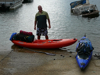
This is Smith with our boats and gear. Notice the partially submerged police boat. It was recovered from the bottom of Fontana Lake two days earlier.


We paddled out of the marina cove and went east across Fontana Lake to Hazel Creek and then up Hazel Creek to a point where the park service had placed a barricade across the creek preventing further upstream travel.

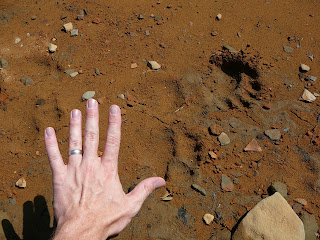
I had read that this particular part of GSMNP had higher concentrations of black bears than in other areas of the park. I had seen one drinking at the lakeshore as we paddled up Hazel Creek. When we got out of our boats on Hazel Creek, we saw this:


Guess they were right! Within an hour of that picture we encountered our second black bear as he came onto the trail from the creek. He was about 30-40 feet in front of us. With the sound of the creek and us being down wind, he never knew we were there until he made it on the trail. Sorry, but I thought safety before photo-op and yelled "Hey Bear!". He promptly sprinted up the hill and out of sight. The rest of the day was scenic, but not as eventful.


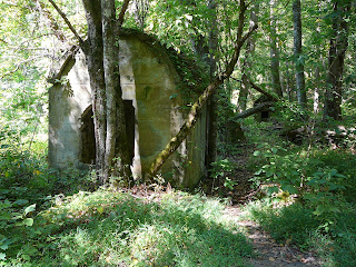
Here are some buildings from what used to be a community (I believe it was Proctor)


We continually gained elevation as we headed for a the last campsite on Hazel Creek. We covered almost 9 miles that day, arriving to camp a couple hours before dark.